It was quite late by the time we dined on the night of the 25th March - around 10.00 p.m. Later Mahalinga Bhat, Narayana Bhat and Nagaraj got into an animated conversation of various piquant stories from Indian myths even as I tried to doze off on a foam mattress. The day was tiring and my body craved for sleep but these guys kept on plodding me to pay attention even as I tried to doze off. Finally I declared that I was feeling too sleepy and that I was signing off for the day. The others too decided to follow suit and it was around 11:30 p.m. when we fell off asleep.
We had declared that we intended to have an early breakfast and leave on the trek for the Pushpagiri peak by 6:30 a.m. so Mahalinga Bhat was up by four in the morning to heat up the water for our baths and to prepare breakfast. He had made what is called Neeru Dosa and coconut chutney. They were truly delicious and we gorged on them. Precisely at 6:30 we set out to the Forest Office having equipped ourselves with the necessary food item like biscuits packets, lime juice bottles, cold freshly churned buttermilk and four packets of MTR ready-made Pongal. After the necessary formalities and payments and a chat with the Forest Guard and his assistants we were on our way to Kumara Parvata.
 |
| KALLU MANTAPA (SHELTER OF STONE) |
 |
| BATTA RASI HILL |
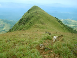
As you tackle this hill there comes into view a taller one called Sesha Parvata (1399 m Lat:12°39'40" Long: 75°40'20") The name again derives from the fact that if you view it from the southern side, it appears like a hooded snake. By the time a person of my age and fitness reaches this place he is usually quite exhausted so I suggested to Nagaraj that we rest. We had arrived at the top of Sesh Parvata at 10:30 a.m. Nagaraj advised that we postpone our rest to a point further on as at the present spot the Sun was bearing down upon us quite intensely and a little beyond there was a wooded region where again water is available. So we proceeded ahead.
After Sesha Parvata the road descends somewhat and there is a shady wooded region that comforts the trekker. You enter the wood and after proceeding for a while you encounter a sheer rocky face at a steep angle. At the foot of the rocky face and on the right there is a water source. The water is very cold and moistens the bottle. We sat around for quite a while here and quenched our thirsts. After sufficient rest we set about for the final climb.
As I said, the first part of the final climb involves scaling of the rocky face. I did not find the ascent too tough even though Nagaraj had expressed the opinion that it could be dangerous. I could tackle it with easy confidence and having done that we executed the final tiring climb to Kumara Parvat.
We arrived at the peak at 11:30 a.m. At the peak the land is a flat table-land and one can find the Survey of India Triangulation point marked by a conical shaped heap of boulders. Some Bajarang Dal activists had stuck a flag on the mound. To the south of the Triangulation point and perhaps 30 meters from it is the temple. The Survey of India toposheet gives its height as 1712 m (5650 ft). It lies in the SOI Toposheet Number 48P/10 (12°39'40"N:75°41'15"E) and lies in the Coorg district of Karnataka. Legend has it that when Subramanya slew Taarakasura, the Devas from the heavens showered a profusion of flowers, and ever since, some variety of flower or the other blossoms throughout the year at this peak. The peak is hence also called Pushpagiri (pushpa = flower; giri = peak)
Triangulation Point of Survey of India.
Height 1712 m
Toposheet : 48P/10
Degree Sheet 48P
Lat:12° 39' 40" N
Long:75° 41'15" E
Location: Kumara Parvata or
Pushpagiri

The temple, obviously quite ancient, has been constructed out of a pile of elliptical rounded boulders. There are three chambers, of which the main one is roofed with a stone slab and the chamber appears like a dark cave. Here you find a Shiva Linga and various articles of pooja like a brass bell, dhoop sticks, match box, oil etc. The entrance is very small and constricted and a man of my size would find it difficult to crawl through.
(Photo on the right: The Temple)
Behind the temple, the rocky basement has the markings of two feet - where lord Subramanya is supposed to have unified with God (attained yoga) in a standing position. Beside the marking of the two feet there are faint traces of some script that reputedly reports the above divine Leela but has almost been rendered obscure by weathering and erosion.
 |
| Shiva Linga in the temple |
Hence on the Girigadde - Kumara Parvata Trek one climbs (1712-868) = 844 m or 2785 feet
To be continued …


No comments:
Post a Comment