Monday, March 26, 2012

Siddara Betta Trek on March 25th 2012 - Continued Part 3


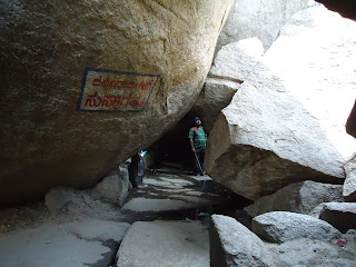
I had decided to first explore the summit of Siddarabetta and only later explore the cave temple and all other caves at a slightly lower level. While we were descending from the summit to the cave temple, Vinod informed me that a Nepali Sadhu had arrived last Monday (we were trekking the following Sunday) and was living in the cave and performing intense Sadhana (extremely rigorous spiritual practices) and had not eaten anything since the past five days. Since he did not know the local language he could not interact with the locals. I was curious to meet this person and interview him if possible. We gradually descended to the level of the cave temple, removed our footwear and devoutly entered the cave.


We were shown the Shiva Linga and is called Siddeshwara. It is a tiny black linga with a hooded serpent of metal. It was adorned with flower garlands and other assorted flowers like hibiscus. After a brief prayer we decided to venture deeper into the cave.


Rugged Path to Rudra Muneeshwar Gaduge
As we negotiated low hanging rocks on top and rugged boulders strewn on the floor, we arrived at a bright chamber. We saw two tiny rooms both of which had doors that were closed. Vinod informed me that the Nepali Sadhu was in one of the rooms. I made a somewhat hesitant effort to rouse the sadhu to open the door. I spoke out loud in Hindi that I had been to Nepal and to Katmandu and asked if I could speak to him. I was feeling extremely hesitant as I was afraid I might be interrupting his spiritual practises. Vinod later tapped on the door and presently he opened a tiny window with an iron mesh screen and briefly acknowledged us. Not wishing to disturb him further we bade farewell and proceeded deeper into the cave.  We had to crawl through about twelve feet of extremely low hanging rock with barely three feet clearance and then emerged to a somewhat spacious chamber that was quite dark. We lit our electric torches and were surprised to find a few monkeys even here.

Low roofed caves to be negotiated


Jeevantha Samadhi (Live grave) of Venkatappa Avadhutha
Vinod pointed to a rocky platform and said that this was what was called in Kannada as the RudraMuneeshwara Gaduge (Rudramuneeshwara's Seat) where the Sadhu was supposed to have lived during the reign of Kurangaraya.  Just four or five feet opposite this platform was a mound with a slit to one side and which Vinod said was the Jivanth Samadhi (live grave?!) of Venkatappa Avadhootha. My guru later told me that this Venkatappa is quite different from the Guru of Shirdi Sai Baba.  Vinod further explained that the slit was there in the mound to facilitate the prana of Venkata Avadhutha who, they all believe, is still alive in the grave.


All the fotos that I have put in the blog are from a still camera with a flash. A video camera recording would have been quite spectacular. I provide a link to a video recording further below.

Meditating on Rudramuneeshwara Gaduge (Seat)

I sat on the Rudra Muneeshwara Gaduge and meditated for a few minutes. Later we explored a small underground source of refreshingly cold sweet water just beside the Gaduge. This spring is called Suvarnagundi as the hill is also known as Suvarnagiri. Vinod asked me if I was game to have a bath in that water. When I eagerly assented (I had brought a spare underwear and towel from Bangalore based on my readings of other blogs) he made me sit on a rock about five feet away,  fetched a vessel and poured out five large measures of water on my head.


The spring named Suvarna Gundi
After drying myself with a towel and dressing up, we decided to retrace our path to the exit. On our way back we were happy to find that the Nepali Sadhu had flung the door of his room wide open. He invited us to be seated and spread a mattress. On enquiry we found that his name was Jyoteshwar Das and that he was from a location near Pashpathi Nath temple in Katmandu, though he presently lived in some other remote part of Nepal. We were surprised to hear he was only 27 years old and had had also lived in Texas and New York where he had worked in the accounting line. His guru's name was Balak Das and was supposed to have been from South India. His guru had advised him to move to the south of India and by some convolute route and with the help of some person he met, he found himself in the caves of Siddarabetta. 


Jyoteshwar Das - the Nepali Sadhak in the cave at Siddarabetta

He said he had acquired some power over his bodily needs through intense sadhana. He said that though all these local villagers were saying that he had not eaten for five days, he had a meager stock of beaten rice (poha in Hindi) with which he was feeding himself somewhat. He later informed us that he was getting intuitive messages that his friend was in some need and that he had to leave for Tumkur immediately. Presently Karthik, Jyoteshwar Das and I descended to the foot of the hill after paying our guide Vinod a small sum of 300 rupees for his guidance.

We reached the base at 3:50 p.m and left for Bangalore at 4:10 p.m. The speedometer reading was 83115 at Siddarabetta. This time we headed towards Tumbadi and Koratagere and thence to Dobbspet and Bangalore. We had a break of about 50 minutes at Uradigere where Karthik wanted to buy fresh vegetables. It is only after we entered the Bangalore Division from the Tumkur Division on
SH3 that we found the quality of the road to be good. The other drawback on this route is that there are quite a lot of dangerous curves and the route is rather sinuous. Further, as is the tendency of many rural folk especially in Karnataka there are many unmarked badly constructed speedbreakers that can be quite dangerous to a motorbike rider. The route we had taken in the morning had none of these flaws and we had a safe ride.  On our return journey we were at Yeshwantpur, Bangalore at 7:10 p.m. and reached Rajajinagar (Karthik's house) at 7:30 p.m. The kilometer reading at home was 83218 meaning that it had taken us 103 km on a return journey.


For an interesting short video on exploring the caves at Siddarabetta click on the Youtube link given below: (be sure to connect your speakers !)

http://www.youtube.com/watch?v=oqla6BlT-xw&feature=colike


Thus ended an exhilarating Sunday in the month of March 2012  !


                                                                    Concluded

Siddara Betta Trek on March 25th 2012 - Continued

We arrived at the foot of Siddarabetta precisely at 11:00 a.m. The kilometer reading on the motorbike was 83114.4 but we have to take into account the extra 2 or 3 km distance we made to visit Seebi. This hill falls in the Survey of India Toposheet 57G/2. The map shows that the contours at the foot of the hill are around 880 m  (i.e. around 2900 feet) and the summit is at 1227 m or 4050 feet.  The climbing of the hill hence involves an ascent of roughly 1150 feet.  Devotees buy fruits and offerings to the Deity on top but are rudely deprived of them by aggressive monkeys that boldly pounce on the hapless victims and snatch it away. The ascent is gradual in the initial stages and there are steps of rock slabs laid out in the soil at the foot of the hill. (foto on left)


Gradually the slope becomes more steep and steps have sometimes been cast out of concrete and at other places have been carved out of rock. 


At places railings have been provided for support but at many places where the slope is steep, there are neither steps nor railings. For persons who are not too sure of their feet it is advisable to carry a sturdy walking stick to negotiate slippery rock slopes. This stick would double up as a defence against attacking monkeys.


For a man not in the peak of fitness and who is sixty years old, it would take about one hour to ascend to the cave temple where a Shiva linga with a metal hood of a snake is placed within the cave.  Before you enter the cave you are asked to remove your footwear and a person will guard it for you for the payment of a nominal fee (5 rupees). Be sure to carry adequate supplies of bottled water (can be bought very chilled at Tovinakere by people who follow the route suggested by us, or at Koratagere by people who follow the other route).  We found that the water had retained its coldness even when we reached the summit. For trekkers who wish to snack at the summit we suggest that you carry it from home or from Tumkur. Along the route only cut seasonal fruits - we found muskmelon and watermelon in late March - and of course, bananas are sold. Refreshing cups of tea or salted buttermilk are available at the top for the fatigued.


 I was lucky to meet a youth of about 21 years called Vinod who offered to guide me around the caves and other spots of interest. I was interested in scaling the summit and hence enlisted his help. He is a student and does not specify any fee for his effort but leaves it to your discretion. (Vinod's Mobile No. 90193 44608  he is available on Sundays and holidays) He took us first to the summit which you have to reach by crawling through crevices formed in the rock. (see foto on right)


By weaving through boulders and crevices we reached what is called the Ardha Chandra Sarovar at some distance below the summit. This is a tiny pond with water filled with algae that gives it an ominous green colour.


 Further ascent takes you to the ruins of a fort at the summit.  Our guide Vinod tells me that these were built in the 16th Century by a local chieftain called Kurangaraya.  He also tells me that the hill has been referred to as Suvarnagiri.  It was during Kurangaraya's time that Siddhi Purushas like Rudramuneeshwara inhabited the caves that are found on this hill.
But more about that later !


From the summit you get spectacular views of the surrounding terrain as seen in the following photographs:


View from Summit


Karthik and Vinod view the scarp face


There is another Shiva temple with a linga on the summit. The summit has a sheet layer of granite that forms an impressive tabletop like structure. The foto on the left shows Karthik and Vinod approaching the Shiva temple fashioned out of rock slabs.


The Shiva Linga inside the temple.


A Panoramic view from a point midway up the hill (scene formed by fusing photographs)


                                                                                     Continued in Part 3 ...

The Siddara Betta Trek on March 25th 2012

These days with excellent technological support like Google Earth, and to a lesser extent Google Maps, one can really plan well for a trek from Bangalore to a place like Siddarabetta. I began by consulting various blogs on this topic and had mustered up a lot of useful information. Most of the blogs had favoured the route from Bangalore to Dobbspet by National Highway 4 (48) and thence taking the Dobbspet - Koratagere road that passes through Uradigere and Irakalsandra which is connected by Karnataka State Highway No. 3. The SH 3 joins SH 33 and at the junction one has to turn eastward to reach Koratagere.  We were advised to proceed along the same road a further six km beyond Koratagere to a place called Tumbadi where a conspicuous arch in Kannada to the left announces the road to Siddarabetta which is about 10 km west of Tumbadi.

Many blogs had complained about the quality of the road to Koratagere from Dobbspet we hence decided to try out an alternate approach. We consulted Google earth and decided to proceed up to a village called Nelahalu which is on the eastern side of the National Highway and is accessed by electing to turn on to the right at the median on the National Highway at 90 Km stone, and entering the Service road and proceeding about a kilometer or two to the north to reach Nelahalu.


                  (A motorbike turning into the road to Tovinakere from Nelahalu)

At Nelahalu a road branches off to the east to Tovinakere which is exactly 10 km from Nelahalu. On proceeding another kilometer along the same road we encounter a village called Jonigarahalli and just beyond the village  a road veers off to the left to Siddarabetta. Siddarabetta is about 8.5 km from Jonigarahalli.


After Jonigarahalli village the road branching off to left to Siddarabetta


The advantage of this route to Siddarabetta from Bangalore is that one travels on a very good road - the National Highway 4(48) for most of the distance. The road from Nelahalu to Tovinakere is quite bad at places but is mostly in quite a serviceable condition. One has to negotiate only 10 km of bad road and that too till Tovinakere and then again the road from Jonigarahalli to Siddarabetta - a distance of 8 km is in very good condition.

Just to test out the condition of the road from Siddarabetta to Bangalore via Koratagere-Uradigere-Dobbspet, we chose that route for our return trip and we felt that we had enjoyed the other route through Nelahalu-Tovinakere-Jonigarahalli better and felt it was more comfortable. I have to mention here that on the Bangalore-Nelahalu-Siddarabetta route one travels about 8 or 9 Km more but this is offset by the road being very much better.

We made the trip by a motorbike and hence has mobike riders as target audience. I specifically say this because mobikes are exempted from paying any fee or waiting in a queue at all toll stations enroute. Car owners may have to shell out a payment of 25 rupees thrice, adding to a total expense in tolls of about 75 rupees.

I was joined in this trek by my former colleague Karthik who works for the Geological Survey of India as a photographer. He is junior to me by almost thirty years and has a greater agility and fitness to negotiate the hill slopes, and at crucial times, he was very helpful as he carried my knapsack in addition to his own.

We left my friend's house at Rajajinagar precisely at 6:30 a.m. with the kilometer reading at 83000. About 5.5 ltrs of petrol was filled and our first stop was at Kamat Upachar at a reading of 83044. This Highway Restaurant comes about 1.5 km before Dobbspet.


The restaurant was of average quality and for a plate of Masala Dosa and a plate of two idlis and a vada and one coffee we paid roughly 90 rupees.


An adjacent building with an attractive facade sported the name 'Fleurs - Clean Toilets'. We were pleasantly surprised to find this announcement, but inside the ugly Indian had violated the wash basins with paan spittle and had not taken care to wash off the stains. There were empty mineral water bottles strewn about too.


After a comfortable breakfast we were on our way and just before Dobbspet we saw a roadsign announcing a deviation to Siddarabetta. We  briefly contemplated whether to elect this route, but decided to go ahead with the plan of going through Nelahalu. We never stopped anywhere and had a continuous ride to Nelahalu.

At the 90 km stone (uprooted by vandals?) we crossed the median and entered the service road to Nelahalu. Karthik had heard of a Narasimhaswami Temple at a place called Seebi in the vicinity of Nelahalu (about a mile further up along the highway). He was keen to visit the temple and offer prayers there. We hence spent about 20-30 minutes there before heading along the road to Tovinakere.


Distant view of Siddarabetta at the rear


                                                                                        Continued in Part 2  ...

Monday, March 12, 2012

An Immigrant's Extraordinarily Inspirational Story

This is a TED Talk by Tan Le who escaped from Vietnam in what was disguised to be a fishing vessel. They ran the risk of capture by the Vietnamese and later faced the threat of attack by pirates. She says her mother was armed with a bottle of poison  - first to be swallowed by Tan Le and her sister, and then by her mother and grandmother in the event of capture!

Listen to this extremely moving tale of an immigrant who ifrst moved to Australia and thence to the U.S.

Tune up your speakers and click on the link below:

http://www.ted.com/talks/tan_le_my_immigration_story.html


Deepak